GIS5100 Week8: Planning-- Location Decisions
This week we were introduced to urban planning. The lab assignment required 2 location analysis maps in order to help a professional couple find suitable suggestions on where to live in Alachua County, Florida.
This hypothetical couple consists of a cardiologist that works at the North Florida Regional Medical Center, and a professor looking to work at the University of Florida. Their priorities are as follows:
This hypothetical couple consists of a cardiologist that works at the North Florida Regional Medical Center, and a professor looking to work at the University of Florida. Their priorities are as follows:
- Close to the NF RMC
- Close to University of Florida
- A neighborhood with high percentage of people ages 40-49
- A neighborhood with high property values
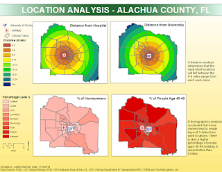
I was able to perform a location analysis for all 4 desired criteria in the map below. This analysis determined that the most ideal areas will fall between 0-9 miles from their work places.
A second analysis was done doing weighted overlays based on criteria importance. The first map on the left shows an overlay in which all 4 criteria have 25% weight. The second on the right favors distances from work with an 80% shared weight (40% for each job), and 10% for ages and house ownership areas.
I thought this was an extremely handy exercise as it can serve to help make big decisions in our own lives. Using basic County and State Census data can be extremely useful tools for location analysis.


Comments
Post a Comment