Posts

Showing posts from September, 2016

Week 5 Lab- Projections Pt. 1
Image
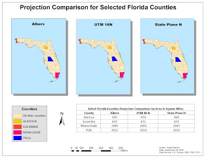
Purpose: To view and project data into three different projected coordinate systems in ArcMap. Then quantify the difference in area between data displayed in the three projected coordinate systems  and map them in multiple data frames. The big task this week was comprehending how Projected Coordinate Systems work, why they're important, and how they apply to a map you create. To lay this out, we worked with a single shape file for the state of Florida and modified the coordinate system using ArcToolbox. In order to view the differences in Projected Coordinate Systems, a number of counties had to be selected and highlighted in the maps using Attribute Tables for each layer. Then the area of the four counties was calculated and recorded on a table to include in the map below.
Week 4 Lab- Sharing GIS

Image
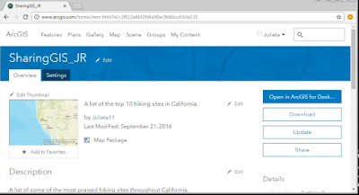
Purpose of lab: Create a "Top 10" list, map the data compiled from scratch, then share content via ArcGIS Online, and Google Earth. For starters, usually we only need access for MS Word and ArcMap. The following items were necessary for this particular lab.: ArcMap Excel (or Google Spreadsheets) MS Word arcgis.com account Google Earth I enjoy going on hiking adventures from time to time with loved ones and have been fortunate enough to visit a decent number of locations in my home state. California is huge though, I'm sure there's plenty I have not heard of yet. With that in mind,   I decided to go with top hiking spots in California using information off  exploretheusa.com  f or my "Top 10" list. Residents can be very territorial here when expressing benefits of particular regions. So I tried to select a list that seemed balanced and included locations throughout the state. Next we gathered specific data about these 10 locations: Rank, Name,

Week 3 Lab- GIS & Cartography

Image
Purpose of lab:   Learn how to utilize ArcCatalog, continue exploring data layouts and symbology options, exporting data, customize raster files, how to create maps, manipulate cartographic data, how to organize manage multiple data frames, and manipulate legend information. There was a wealth of information to process and continue to absorb this week. Without having experienced many other GIS fields of practice yet, I do have a keen interest in Cartography and want the challenge of learning if it's for me. We had the opportunity to utilize ArcCatalog and see how it is linked to ArcMap for map making. I loved the pin feature in ArcMap! It's very handy being able to simply drag and drop data files onto a blank map file from ArcCatalog once you've organized data files. Below I will further recount my experiences while creating three different maps of Mexico. Map 1: States of Mexico by Population This map exercise allowed to practice layer management in the To

Week 2 Lab- Own Your Map!

Image
This week’s lab allowed us to go a bit deeper in customizing a map in ArcMap. Last week we had the opportunity to explore feature placement and get a feel for prioritizing the information needed. This exercise was a challenge in that it introduced how to add an inset map while still communicating where it fits in a regional map, or part of it. The more thought I put into how it could be read by a random person, the more complex something such as color selection became. ...Not that I was stuck here for two hours. But it was something new I learned while going through the steps. This was important. More important though was focusing on the goal of this map, which was to direct someone to the UWF campus on a general map of Escambia County in Florida. I found the steps in customizing land features, such as roads and rivers, very useful. To be honest, I had not put that much weight into selecting a clear color choice for these before. But they’re equally significant to stand out against t