GIS4035 Module 10-- Supervised Image Classification
This week we had to produce a classified image from satellite data using the supervised image classification method.
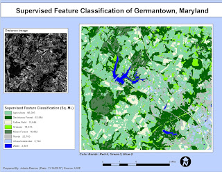
To do this, first, I identified fourteen land cover types based on an original satellite image for Germantown, Maryland using the Inquire Cursor and Signature Editor in ERDAS Imagine. Then modified the band colors to better suit the features being represented. From there, I re-coded each class down to have eight as there were a few land cover types that repeated. This process required to create two additional images that incorporated these classes: a supervised image, and a distance image. I did another color pass in the new supervised since it is easier to have unique colors for eight classes. The final part of this map was completed in ArcMap, both of my own new images are represented here. While the supervised image displays the required eight land cover types, the distance image serves to show feature variances in color. The features with the brightest pixels here mean that they might have an incorrect classification.


Comments
Post a Comment