Posts

Showing posts from July, 2018

GIS5100 Week9: Planning-- GIS for Local Government
Image
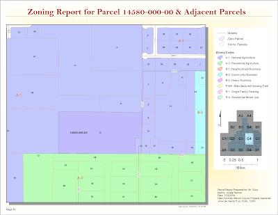
For this last module, we were given a parcel number to create a parcel report for a specific site in Marion County, Florida and its adjacent parcels. I prepared a map book using Data Driven Pages for this request using parcel data driven pages in PDF format. The map below is one page from it which displays the parcel in question. I learned all about creating and editing a parcel report to deliver to the fictional client in this scenario, Mr. Zuko. The map book feature in ArcGIS is a fantastic tool, I learned. The zoning report above was completed using data directly from the Marion County property appraiser's site and Marion County's  Land Development Code site . Part two of this lab required to identify suitable parcels for Gulf County's Board of County Commissioners (BOCC) new extension office. It required learning some advanced parcel editing methods such as creating a custom parcel based on the following client specifications: Begin at the Northeast Corner 

GIS5100 Week 8-9: Planning-- Participation Activity

Image
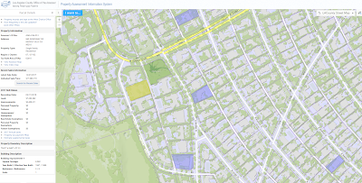
As part of our section in Planning, we completed this additional exercise in learning where to search for local parcel data in our city and what type of information is necessary to conduct a parcel report. There are a few property appraisers in Los Angeles County, it seems. This one offered some free map data services  here . While did not provide a filter to narrow down highest priced properties by year. I did find a property that sold for 17 million last year in the Beverly Hills area. The current assessed land value is $7,263,892. No previous sale price is included in this assessment. While there's limited information about recently sold properties, there is an assessor's map for this property  here . It was interesting to learn that the County updates Parcel data on this site once a year in late July once the Assessor’s Roll Release is complete. This site is fairly limited, all things said. For example, I am unable to view much data about other nearby parcels t

GIS5100 Week8: Planning-- Location Decisions

Image
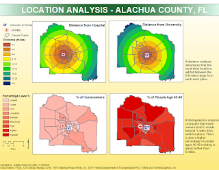
This week we were introduced to urban planning. The lab assignment required 2 location analysis maps in order to help a professional couple find suitable suggestions on where to live in Alachua County, Florida. This hypothetical couple consists of a cardiologist that works at the North Florida Regional Medical Center, and a professor looking to work at the University of Florida. Their priorities are as follows: Close to the NF RMC Close to University of Florida A neighborhood with high percentage of people ages 40-49 A neighborhood with high property values I was able to perform a location analysis for all 4 desired criteria in the map below. This analysis determined that the most ideal areas will fall between 0-9 miles from their work places. A second analysis was done doing weighted overlays based on criteria importance. The first map on the left shows an overlay in which all 4 criteria have 25% weight. The second on the right favors distances from work with an 80

GIS5100 Week7: Homeland Security-- Protect Critical Infrastructure

Image
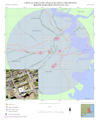
This lab marks the last week for Home Land Security. Last week we were introduced to an organizational standard for a HLS Geodatabase consisting of 7 group layers covering essential data sets in a HLS scenario for the Boston Marathon bombing in 2013. This week we put those data sets to use to produce a scenario map for critical infrastructure and a second map for site surveillance locations around critical infrastructure. This first map contains information which local towns/cities, and buildings are located within 3 mile radius from the Finish Line. Using Census data, I was able to narrow down a list of nearest hospitals, the closest one being Boston Emergency Medical Center. There were a total of 49 hospitals, 2 dams, 7 airports, and 213 schools-- all of these are considered critical infrastructures. Using Road CFCC code data, I then identified ingress and egress routes within 500 ft. from the Finish Line. These routes would be used to closely monitor suspicious activity as people