Week 13-16- Final Project

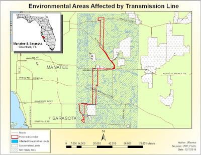
Purpose: This final assignment placed us in the position of a real GIS analyst for the energy company Florida Power and Light (FPL). The task being to analyze key components that had been considered in gaining right-of-way acquisition for the approved Bobwhite-Manatee Transmission Line Project-- a real life project. We are to choose the best route which is both economically and minimally invasive to the environment and communities in Manatee and Sarasota counties using a more generalized and scaled-down version of the original project survey done in 2009. ... Easy, right? It was really helpful to have started this assignment by creating a Cartographic Model and working from there to best organize the data needed each step. Every step required to go back and reference previous lessons from this course. It was as much a challenge as a refresher. Below is 1 of 5 maps done for this final project. Along with the main project analysis, we had to assemble a powerpoint presentati