Posts

Showing posts from April, 2017

Module 12- NeoCartography
Image
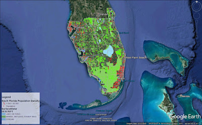
As we get closer to the end of this course it is fitting that we focus on modern trends in Cartography and where it's headed. Concepts covered this week are: the concept of Volunteered Geographic Information, Public Participation GIS, Geocollaboration, Geotargetting, Cloud Computing and Cloud Based GIS. This week's lab consisted of two parts: Create a shareable web map utilizing the data created in Module 10- Dot Density Mapping. Create an interactive Google Earth tour (fun!) Objectives here being to use our data from Module 10 Dot Density map lab to present in Google Earth and to create a Google Earth Tour of major cities in South Florida. Below is a screenshot captured in Google Earth of my South Florida Population Density map. This was done by first stripping down the original map in ArcMap and using the Map to KML and Layer to KML tools to convert my files from .mxd to .kmz file type. This allowed them to be opened in Google Earth. The second part to this w

Module 11- 3D Mapping

Image
This week's lab consisted of three parts to cover 3D Mapping: ESRI Training course: 4D Visualization Techniques Using ArcGIS Converting 2D data to 3D 3D Concepts Continued: City Engine and Minard's map of Napoleon's Russian Campaign of 1812. Part one was lengthy but very fun, I thought. Using ArcGIS, ArcScene, and Google Earth, we were tasked with learning techniques to visualize feature data in 3D such as buildings, wells, streams, towers, and vegetation. It was really neat seeing how basic data came together to visualize an environment in 3D. Techniques covered in these exercises included: setting base heights for raster and feature data, setting vertical exaggeration, setting illumination, extruding buildings and wells, and extruding parcel values. Everything learned in part one were essential in part two. We were given a set of 2D data and converted it to 3D then implemented it in Google Earth. Part three was interesting to think critically abou