Posts

Showing posts from November, 2016

Week 12- Georeferencing
Image
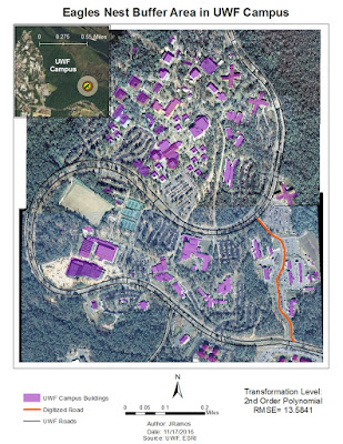
Purpose: To become familiar with Georeferencing, Georeference data using the Control Points tool, Georeference an unknown raster image of the campus to known vector data, interpret Residual and Root Mean Square errors, digitize new building and road features, practice polynomial transformations, create hyperlinks in ArcGIS to stored data, create Multiple Ring Buffers, customize an ArcMap toolbar, overlay data in a 3D environment. Overall, this was a fairly light lab, but very time consuming in trying to adjust the aerials just right so the image is as straight as possible. The goal here was to georeference two raster images of the UWF campus and have less than 15 RMS error, which I did. In addition to this, we had to create a multi ring buffer (MRB) surroind nearby eagles nests. The second portion of this map deliverable included a 3D map done in ArcScene of the aerials we georeferenced previously.

Week 11- Geocoding

Image
Purpose:  Create an address locator, conduct geocoding via address matching, conduct a route analysis using the Network Analyst extension, and analyze data in a model using ModelBuilder. It may not sound like much, but this lab was heavy in content to communicate. I have been curious about how professionals apply GIS to day to day utilities and managed to get a brief glimpse of what's involved. It also served to comprehend just how critical it is for the GIS technician or cartographer to provide the most accurate and up to date data possible. For this main exercise, we had to geocode 21 Emegency Medical Services locations within Lake County, Florida. Some sites had no matching addresses which had to be researched using the LakeEMS.org site and Bing maps in order to place them on the map correctly. In addition to mapping EMS locations, we had to select 3 random sites and find the most optimal route. The map below shows my results. \ The second part of this lab required to

Week 9 &10 Labs- Vectors!

Image
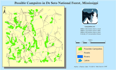
ArcPy is the best!... Let's backtrack a bit to review material covered the past two weeks. During week 9, we went through sorting, specified Selections, and Joins in ArcMap using different types of shape files. I'll be repeating the exercise using different scenarios and conditions to make sure I attain a solid understanding of those tools before our final project. Not to mention that it feels like I will be utilizing those tools on a regular basis in the future. Week 10 we continue our lesson in Vectors by going over Buffers,  Overlay types, and Data Management tools in ArcToolbox. We also reviews some basics of how to use ArcPy. Granted the lab only covered a simple, yet handy, reason to use it by creating new layers with modified buffer settings. But I'm looking forward to playing with it in the near future. Below is the result of this week's lab which demanded to isolate possible campsites in the De Soto National Forest in Mississippi that were 300m from roads, 15