Week 12- Georeferencing
Purpose: To become familiar with Georeferencing, Georeference data using the Control Points tool, Georeference an unknown raster image of the campus to known vector data, interpret Residual and Root Mean Square errors, digitize new building and road features, practice polynomial transformations, create hyperlinks in ArcGIS to stored data, create Multiple Ring Buffers, customize an ArcMap toolbar, overlay data in a 3D environment.
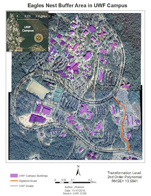
Overall, this was a fairly light lab, but very time consuming in trying to adjust the aerials just right so the image is as straight as possible. The goal here was to georeference two raster images of the UWF campus and have less than 15 RMS error, which I did. In addition to this, we had to create a multi ring buffer (MRB) surroind nearby eagles nests.

Overall, this was a fairly light lab, but very time consuming in trying to adjust the aerials just right so the image is as straight as possible. The goal here was to georeference two raster images of the UWF campus and have less than 15 RMS error, which I did. In addition to this, we had to create a multi ring buffer (MRB) surroind nearby eagles nests.

The second portion of this map deliverable included a 3D map done in ArcScene of the aerials we georeferenced previously.


Comments
Post a Comment