Week 9 &10 Labs- Vectors!
ArcPy is the best!... Let's backtrack a bit to review material covered the past two weeks. During week 9, we went through sorting, specified Selections, and Joins in ArcMap using different types of shape files. I'll be repeating the exercise using different scenarios and conditions to make sure I attain a solid understanding of those tools before our final project. Not to mention that it feels like I will be utilizing those tools on a regular basis in the future.
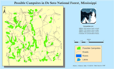
Week 10 we continue our lesson in Vectors by going over Buffers, Overlay types, and Data Management tools in ArcToolbox. We also reviews some basics of how to use ArcPy. Granted the lab only covered a simple, yet handy, reason to use it by creating new layers with modified buffer settings. But I'm looking forward to playing with it in the near future. Below is the result of this week's lab which demanded to isolate possible campsites in the De Soto National Forest in Mississippi that were 300m from roads, 150m from lakes, 500m from rivers, and were located outside of conservation areas.
Week 10 we continue our lesson in Vectors by going over Buffers, Overlay types, and Data Management tools in ArcToolbox. We also reviews some basics of how to use ArcPy. Granted the lab only covered a simple, yet handy, reason to use it by creating new layers with modified buffer settings. But I'm looking forward to playing with it in the near future. Below is the result of this week's lab which demanded to isolate possible campsites in the De Soto National Forest in Mississippi that were 300m from roads, 150m from lakes, 500m from rivers, and were located outside of conservation areas.


Comments
Post a Comment