Posts

Showing posts from July, 2017

Peer Review Assignment #2

This peer review takes a look at A new GIS-based model for automated extraction of Sand Dune encroachment case study: Dakhla Oases, western desert of Egypt found in the UWF Journal's resources database. Sand dunes are considered a threat for roads, water sources, agriculture, irrigation networks, and infrastructures in the Dakhla Oases in the western desert region of Egypt. The focus of this paper is to develop a new GIS based model for automated extraction of sand dune encroachment using remote sensing data to assess the rate of sand dune movement. The paper is a group effort amongst staff from the Department of Remote Sensing and Landscape Information Systems (FeLis) at Freiburg University, Germany, and the Land Use Department at the National Authority for Remote Sensing and Space Sciences (NARSS) in Cairo, Egypt. This particular case study was published in Volume 15, Issue 1 of The Egyptian Journal of Remote Sensing and Space Science in June 2012. The data provided for this c

Module 9- Working with Rasters

Image
Last week we focused on vectors, this week we looked at working with rasters in Python. This lab assignment required to write a script that does the following tasks: creates a raster output file that identifies areas with specific parameters (slope, aspect, and land cover type). The flowchart to the right displays simplified steps taken in the script. Using two rasters, for landcover and elevation, the final raster highlights areas that suit the following criteria: Forest landcover consists of classifications 41, 42, and 43 Slope falls between 5-20° Aspect ranges between 150-270° Below is the script output: and the final raster image:

Module 8- Working with Geometries

Image
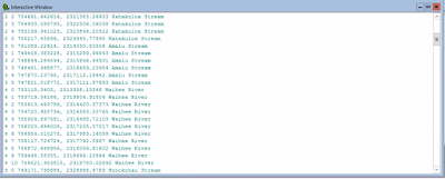
This week's exercises demanded hands on writing multiple scripts that worked with geometries in a shape file and text file in order to produce a poly line. I've never done this type of script, so it was really interesting going through the steps to find points, find lengths, and define an area using just a script and coordinates in a text file. For the lab, I wrote a script that creates a new text file in which it writes the Object IDs for the vertices in a shape file and the coordinates. To be honest, I had some troubles working backwards in the retrieval of coordinates part as well as writing all the vertices into the text file. Below is part of the script output.

Module 7- Exploring & Manipulating Spatial Data

Image
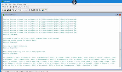
This week we will learn how to read, update, and manipulate data using lists, dictionaries, cursors, and loops. The lab itself was well designed in breaking down all steps necessary which consisted of the following tasks.: Create a new Geodatabase. Set a current workspace which includes Data output folder. Created variable fclist to get a list of all feature classes in the data set. Created a for loop to copy over all features from the workspace to the new Geodatabase. Created a Search Cursor for cities layer filtering city names and populations that met the criteria. Created an empty dictionary and populated it with cities and their populations using a for loop. Added "Process complete!" messages to each step as validation that a step had been completed. Below is the output for all steps completed. The most difficult step was creating a  for  loop for the last requirement in order to populate the dictionary. I was going down the wrong path for a while