Posts

Showing posts from August, 2017

GIS5935 Week 1-- Data Quality: Fundamentals

Image
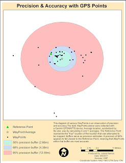
For our first lab in Special Topics in GIS we looked at what accuracy and error mean in the context of Data Quality. In this first part of the lab I calculated the average WayPoint based off WayPoints gathered from a Garmin GPSMAP76 unit in order to find the precision of a specific location. Average location was determined by calculating X and Y averages. In the diagram below, the Reference Point represents a the "true" location of the location that was attempted to be mapped. Buffers of 50%, 68% and 95% precision were also calculated to observe the precision of the data. For the second part of the lab, we had to calculate error metrics for another and larger set of GPS points and create a Cumulative Distribution Function graph showing the error distribution for all metrics.

Orientation Assignment - Own Your Map

Image
As part of Orientation week for this course we reviewed some basics from the Introduction to GIS course. We were given a template map of Florida counties. We had to create a map for the UWF campus in Escambia County using data provided by FGDL which included: Escambia County, major roads, and rivers. Roads and rivers were clipped to fit the county shape. The font titles, County map colors, data frame background colors and frames, symbols for the UWF campus, Interstate, and River were all customized. I have not had to create a map in ArcMap recently, so this was a nice refreshing exercise to get back in practice.

Module11- Sharing Tools

Image
This module served very much as a review in Script Tools. The assignment required that we edit an existing script to work with data provided, edit parameter details for the tool to become more user friendly, then finalize it by embedding the script into the tool and creating a password for it.  This is the final outcome of tool. It was supposed to create randomized points with buffers within the feature boundary.  Below is a flowchart displaying basic steps taken to create and share this Script Tool. ...and that's a wrap! This was the last module for GIS Programming course. I still have the final project to complete for next week. While it's not the end yet, there is a sense of accomplishment in having made it this far in a course I thought I would perform terribly in. All modules focused on Python fundamentals were very challenging for me but also the most rewarding once I figured things out. It was really helpful being familiar with how certain tools wor

Module 10- Creating Custom Tools

Image
This week we reviewed some Script Tool fundamentals. The lab required that we modify a stand alone script to perform a multi clipping task in ArcMap. First, I tested the script in PythonWin to make sure it worked. Then created a new Toolbox in ArcMap, added a new Script Tool, and linked the stand alone script here in order to use it. Next was modifications to the Script Tool parameters and script to make it work in ArcMap. Below is an image of the opened Script Tool displaying both input and output locations, meaning that the new parameters were working as expected. After making some code adjustments to the script and editing variable values to point to the desired parameters for Output Boundary Feature and Input Features. The tool dialog box below displays a successful task completed listing all the shape files being clipped in the process. There are definitely more steps in the process of creating a new custom tool for ArcMap while the script may be simpler. Bel