Posts

Showing posts from January, 2017

Module 2- Introduction to Adobe Illustrator
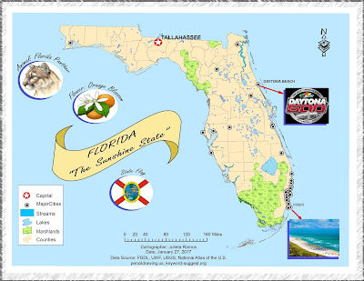
Image
This week we explored utilizing both ArcMap and Adobe Illustrator to create and enhance a basic map of Florida for a children's encyclopedia. I wound up spending a lot more time on this assignment than expected since it was my first time enhancing a map from ArcMap. Layers needed some readjusting before I felt comfortable adding graphics. Color scheme wise, I decided to keep it light and simple, it's for kids after all. That dictated the choice of font and border style used as well as the title. There were a lot of images in this map that could drown out the title. So I figured it was best to make a banner for it to stand out. This is actually the second map because while working through the lab document the first time, I realized that my initial Florida map layout did not suit the layout I worked towards in AI. When I was ready to work on a finalized version, knowing the audience and content required drove the layout.

Module 1- Map Evaluation & Critique

Image
In this introductory cartography lab, we reviewed some basic aesthetics of what makes a good map and common map design principles. The exercise at hand required that we select two maps of our choice, one which we think is well designed and one poorly designed. Evaluation of a poorly designed map: This selection had to serve as example of nearly everything to avoid when creating a decent informative map. As more of a visual learner, busy displays can be very disruptive and intimidating. I've seen language and dialect maps before and they can very aesthetically pleasing to the eye and inviting to process their information. I would give this map a D letter grade for effort and information alone. My main reasons for a low grade are highly due to the lack to effectively label the map, the general layout is more complex than it needed to be, and it fails to be graphically pleasing. Three areas of improvement I would suggest working on are: layout, labels, and color theme. The t

Cartographic Skills- Introduction

Hi! My name is Julieta Ramos and I’m from Los Angeles, California. I hold a B.A. in Anthropology from the University of California Riverside. During undergrad years, I completed an archaeology field school in Belize, and interned for LULAC in Washington D.C.. Afterwards, I volunteered for the World Wide Organization of Organic Farmers (WWOOF) for 3 months in France and Italy. From there, I worked in CRM and tutored for a few years before falling backwards into the game industry in which I’ve worked my way up from a tester to project and localization manager for a video game studio in town. Having worked in software development for the past 6 years helped steer me back to this field since it continues to play a major role in geographical intelligence and advancements. Earth is ever changing and I see this industry growing fast. I figured this is the right time in my life to invest in a dream career path. Upon discovering GIS during undergrad, I've kept meaning to return to work in