Module 12- NeoCartography
As we get closer to the end of this course it is fitting that we focus on modern trends in Cartography and where it's headed. Concepts covered this week are: the concept of Volunteered Geographic Information, Public Participation GIS, Geocollaboration, Geotargetting, Cloud Computing and Cloud Based GIS.
This week's lab consisted of two parts:
This week's lab consisted of two parts:
- Create a shareable web map utilizing the data created in Module 10- Dot Density Mapping.
- Create an interactive Google Earth tour (fun!)
Objectives here being to use our data from Module 10 Dot Density map lab to present in Google Earth and to create a Google Earth Tour of major cities in South Florida.
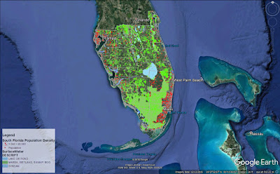
Below is a screenshot captured in Google Earth of my South Florida Population Density map. This was done by first stripping down the original map in ArcMap and using the Map to KML and Layer to KML tools to convert my files from .mxd to .kmz file type. This allowed them to be opened in Google Earth.
Below is a screenshot captured in Google Earth of my South Florida Population Density map. This was done by first stripping down the original map in ArcMap and using the Map to KML and Layer to KML tools to convert my files from .mxd to .kmz file type. This allowed them to be opened in Google Earth.

The second part to this was fun! It took a few practice runs to get the ideal timing and content to show off in the tour. There's definitely a new appreciation for Google Earth every time we've needed to utilize it for an assignment.


Comments
Post a Comment