Week 7&8 Lab- Data Search
Purpose: Perform our own data search consisting of 5 Vectors, 2 Rasters, and 2 Environmental data files of our choice. Final outcome should be 2-3 map layouts showing all 9 data layers.
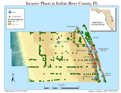
This is our midterm assignment! I was feeling a bit more confident by the end of last week's lab exercise and became humbled after digging into this lab. Plenty of time was spent gathering data and organizing it in the source folder. I did my best to select the appropriate data from the FGDL site. For the 2 Environmental Layers I chose Land Cover and Invasive Plants because they seemed like a good pairing of data and could potentially be affecting each other.
Before opening ArcMap, I also grabbed the necessary DOQQ and DEM files for Indian River County from the LABINS and USGS National Map sites.
Starting with the County boundary map shape file, I decided on the NAD_1983_2011_StatePlane_Florida_East_FIPS_0901_Ft_US coordinate system to reproject all my data to. From the bottom up: County boundary>Public Land>Surface Water>R.org, oads>Cities.
There was a lot of data to manage by this point. Reviewing Layer Properties seemed necessary to check that all data layers lined up under the same coordinate system before going any further. Next was learning how to "Clip" different file types. On the surface, it is comparable to "cropping" a layer in Photoshop, but more complex due to the content of map files.
Finally went back to the drawing board of gathered data to think how to present it all. Below are the three maps from this assignment.


Comments
Post a Comment