Module 5- Geoprocessing in ArcGIS
This week we practiced several types of geoprocessing techniques, including batch processing, making new tools with ModelBuilder, and converting those tools into Scripts and Script tools.
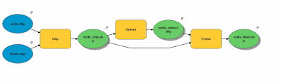
For the lab part, we had to create a model and a script tool to perform two geoprocessing tasks: first to run a query of soils with a specific attribute, and then to erase those soils and produce a final soil shape file. The final model clips, queries, then erases and produces three new shape files (soil_clip, soil_select, and soil_final) as seen below.

For the lab part, we had to create a model and a script tool to perform two geoprocessing tasks: first to run a query of soils with a specific attribute, and then to erase those soils and produce a final soil shape file. The final model clips, queries, then erases and produces three new shape files (soil_clip, soil_select, and soil_final) as seen below.

The final outcome on the map looks like this:

The Soil shape file has been clipped to display Soils that fall within the Basin shape file. Soils with the attribute 'Not prime farmland' have been selected and removed from the final Soil shape file.


Comments
Post a Comment