Week 4 Lab- Sharing GIS
Purpose of lab: Create a "Top 10" list, map the data compiled from scratch, then share content via ArcGIS Online, and Google Earth.
For starters, usually we only need access for MS Word and ArcMap. The following items were necessary for this particular lab.:
I enjoy going on hiking adventures from time to time with loved ones and have been fortunate enough to visit a decent number of locations in my home state. California is huge though, I'm sure there's plenty I have not heard of yet. With that in mind, I decided to go with top hiking spots in California using information off exploretheusa.com for my "Top 10" list. Residents can be very territorial here when expressing benefits of particular regions. So I tried to select a list that seemed balanced and included locations throughout the state.
Next we gathered specific data about these 10 locations: Rank, Name, Address, State, Zip, Image URL. Google Maps is a great tool for this information in case it is not immediately provided in the source. I have to admit that I came across an issue of not finding a Zip code for one of my sites. Google Maps still provides coordinates for such locations. But I wonder, what is the best thing to do in this scenario?
I resolved to using the closest Zip code related to my site because I knew it was part of the same National Park.
Next was geocoding the data gathered by implementing it to a blank map in ArcGIS Online. Then we had to implement the data in a new map in ArcMap. This portion of the lab was a bit tricky since it's new territory and involved going back and forth between the two programs. In the end, ArcGIS Online was very user friendly the more I used it and learned of ways to share content.
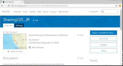
My ArcGIS Online map: http://arcg.is/2cYxfAV

For starters, usually we only need access for MS Word and ArcMap. The following items were necessary for this particular lab.:
- ArcMap
- Excel (or Google Spreadsheets)
- MS Word
- arcgis.com account
- Google Earth
I enjoy going on hiking adventures from time to time with loved ones and have been fortunate enough to visit a decent number of locations in my home state. California is huge though, I'm sure there's plenty I have not heard of yet. With that in mind, I decided to go with top hiking spots in California using information off exploretheusa.com for my "Top 10" list. Residents can be very territorial here when expressing benefits of particular regions. So I tried to select a list that seemed balanced and included locations throughout the state.
Next we gathered specific data about these 10 locations: Rank, Name, Address, State, Zip, Image URL. Google Maps is a great tool for this information in case it is not immediately provided in the source. I have to admit that I came across an issue of not finding a Zip code for one of my sites. Google Maps still provides coordinates for such locations. But I wonder, what is the best thing to do in this scenario?
I resolved to using the closest Zip code related to my site because I knew it was part of the same National Park.
Next was geocoding the data gathered by implementing it to a blank map in ArcGIS Online. Then we had to implement the data in a new map in ArcMap. This portion of the lab was a bit tricky since it's new territory and involved going back and forth between the two programs. In the end, ArcGIS Online was very user friendly the more I used it and learned of ways to share content.
My ArcGIS Online map: http://arcg.is/2cYxfAV

The last part required to create a map package to share on ArcGIS Online and then export the data layer as a KML file to open in Google Earth. This was my first time making and implementing data layers to ArcGIS Online and Google Earth. The symbol color could have definitely use another pass, looking back.
It was very rewarding seeing my small set of data come to life in ArcGIS Online and Google Earth. Not to mention realizing it's not as difficult getting information together after all.


Comments
Post a Comment