GIS5935 Week 2-- Data Quality: Standards
For this second week into standards in regards to Data Quality, we had to perform a horizontal accuracy assessment using NSSDA protocol methodology in order to determine the accuracy of two different street map data sets based off the same area in Albuquerque, New Mexico.
Using two different street sample data sets: City data (ABQ_Streets) and ESRI street map data (StreetMapUSA). I started things off by creating a network data set for each street shape file in ArcMap.
Next, in order to be mindful of the study area and attempt to make sure the points met the criteria, I created a fishnet with 2x2 columns/rows which creates 4 quadrants within the study area.
Working off the Junction layer for ABQ_Streets, I selected 20 intersection test points as suggested. It was encouraged to use the City data set due to it being more accurate.
Then comparing the selected test points, I selected matching test points for the StreetMapUSA data set.
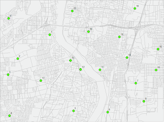
The third and final data set needed for this lab was my own reference data set, which was created by using provided orthophotos and meticulously digitizing where I thought the "true" location of the intersections selected. Below is an image of the reference points.
Using two different street sample data sets: City data (ABQ_Streets) and ESRI street map data (StreetMapUSA). I started things off by creating a network data set for each street shape file in ArcMap.
Next, in order to be mindful of the study area and attempt to make sure the points met the criteria, I created a fishnet with 2x2 columns/rows which creates 4 quadrants within the study area.
Working off the Junction layer for ABQ_Streets, I selected 20 intersection test points as suggested. It was encouraged to use the City data set due to it being more accurate.
Then comparing the selected test points, I selected matching test points for the StreetMapUSA data set.
The third and final data set needed for this lab was my own reference data set, which was created by using provided orthophotos and meticulously digitizing where I thought the "true" location of the intersections selected. Below is an image of the reference points.

Using ArcToolbox's Add XY Coordinates tool, I was able to determine X and Y coordinate for all three data sets.
The final part of this assessment was to calculate accuracy statistics using exported DBF files from each data set's attribute table and a provided Excel file with the necessary formulas.
Accuracy Statement for ABQ_Street data set
- Horizontal Positional Accuracy:
- Tested 24.7 feet horizontal accuracy at 95% confidence level
Accuracy Statement for StreetMapUSA data set
- Horizontal Positional Accuracy:
- Tested 307.4 feet horizontal accuracy at 95% confidence level


Comments
Post a Comment