GIS4035 Module 2-- Aerial Photography Basics & Visual Interpretation of Aerial Photography
For this module's lab, we observed three different aerial images for three different purposes: first served to identify tone and textures, second was identifying physical features, and third was interpreting color. Only two maps were required for the first two exercises.
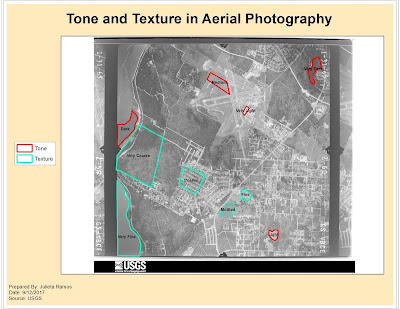
The objective for exercise 1 was to be able to identify texture and tone in an aerial photograph. For both elements, it was required to observe at least 5 different tones and textures (i.e. light, very light, dark, coarse, etc.).
The objective for exercise 2 was to learn how to identify features according to shape and size, shadows, pattern, and by association. I think I did a good job after zooming in and examining the aerial image closer to try and identify features better. Shadows became very helpful in singling out possible trees or street posts which then helped with associating other features nearby.

The objective for exercise 1 was to be able to identify texture and tone in an aerial photograph. For both elements, it was required to observe at least 5 different tones and textures (i.e. light, very light, dark, coarse, etc.).

The objective for exercise 2 was to learn how to identify features according to shape and size, shadows, pattern, and by association. I think I did a good job after zooming in and examining the aerial image closer to try and identify features better. Shadows became very helpful in singling out possible trees or street posts which then helped with associating other features nearby.


Comments
Post a Comment