GIS5935 Week 3-- Data Quality : Assessment
In this assignment, we learned how to determine the quality of road networks by determining their completeness by comparing total lengths of two different road data sets.
Using Calculate Geometry, in kilometers, I was able to determine that TIGER roads were more complete by comparison. Total TIGER Roads length came out to be 11,383 km, while Street Centerlines were 10,805.8 km.
I actually had a more difficult time organizing this analysis than initially expected. The method that seemed to work was to first clip the two roads to the grid shape file. From there run the Intersect tool on both road clips to the grid, separately of course. Then gathered the length info from each road DBF files and added it to a new excel sheet to included GRIDCODE, FID, and Lengths. In this new sheet, I then calculated the percentages using the provided formula of:
% difference = (total length centerlines – total length TIGER) / total length centerlines * 100%
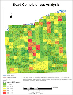
Then I added this sheet to the TOC of the working map file for the lab, made a Join off the Grid shape file and created classes for percentages.
The results conclude that there is a higher percentage difference in completed roads outside of the central area.
Using Calculate Geometry, in kilometers, I was able to determine that TIGER roads were more complete by comparison. Total TIGER Roads length came out to be 11,383 km, while Street Centerlines were 10,805.8 km.

% difference = (total length centerlines – total length TIGER) / total length centerlines * 100%
Then I added this sheet to the TOC of the working map file for the lab, made a Join off the Grid shape file and created classes for percentages.


Comments
Post a Comment