GIS5100 Week7: Homeland Security-- Protect Critical Infrastructure
This lab marks the last week for Home Land Security. Last week we were introduced to an organizational standard for a HLS Geodatabase consisting of 7 group layers covering essential data sets in a HLS scenario for the Boston Marathon bombing in 2013.
This week we put those data sets to use to produce a scenario map for critical infrastructure and a second map for site surveillance locations around critical infrastructure.
This first map contains information which local towns/cities, and buildings are located within 3 mile radius from the Finish Line. Using Census data, I was able to narrow down a list of nearest hospitals, the closest one being Boston Emergency Medical Center. There were a total of 49 hospitals, 2 dams, 7 airports, and 213 schools-- all of these are considered critical infrastructures. Using Road CFCC code data, I then identified ingress and egress routes within 500 ft. from the Finish Line. These routes would be used to closely monitor suspicious activity as people make their way in and out of the Finish Line area.
I really enjoyed this second part in which we had the chance to test out different security point locations in order to have a clear line of sight of the Finish line. The process was new to me and it made it feel like I've gained a new level of appreciation for all that HLS teams do in an attack crisis situation. There's so many moving parts to consider in a moment when it may not clear how many targets there are, and as GIS specialists we're only being exposed to critical data necessary in those situations.

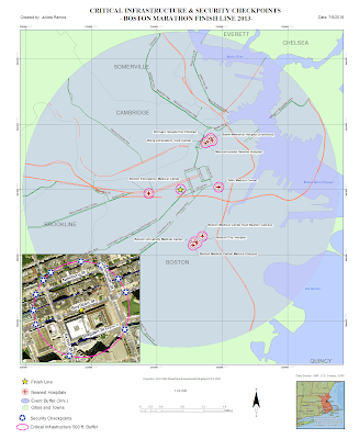
This week we put those data sets to use to produce a scenario map for critical infrastructure and a second map for site surveillance locations around critical infrastructure.
This first map contains information which local towns/cities, and buildings are located within 3 mile radius from the Finish Line. Using Census data, I was able to narrow down a list of nearest hospitals, the closest one being Boston Emergency Medical Center. There were a total of 49 hospitals, 2 dams, 7 airports, and 213 schools-- all of these are considered critical infrastructures. Using Road CFCC code data, I then identified ingress and egress routes within 500 ft. from the Finish Line. These routes would be used to closely monitor suspicious activity as people make their way in and out of the Finish Line area.

I really enjoyed this second part in which we had the chance to test out different security point locations in order to have a clear line of sight of the Finish line. The process was new to me and it made it feel like I've gained a new level of appreciation for all that HLS teams do in an attack crisis situation. There's so many moving parts to consider in a moment when it may not clear how many targets there are, and as GIS specialists we're only being exposed to critical data necessary in those situations.


Comments
Post a Comment