GIS5100 Week9: Planning-- GIS for Local Government
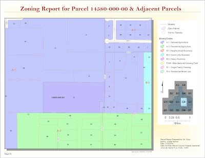
For this last module, we were given a parcel number to create a parcel report for a specific site in Marion County, Florida and its adjacent parcels. I prepared a map book using Data Driven Pages for this request using parcel data driven pages in PDF format. The map below is one page from it which displays the parcel in question.
Part two of this lab required to identify suitable parcels for Gulf County's Board of County Commissioners (BOCC) new extension office. It required learning some advanced parcel editing methods such as creating a custom parcel based on the following client specifications:

I learned all about creating and editing a parcel report to deliver to the fictional client in this scenario, Mr. Zuko. The map book feature in ArcGIS is a fantastic tool, I learned. The zoning report above was completed using data directly from the Marion County property appraiser's site and Marion County's Land Development Code site.
Part two of this lab required to identify suitable parcels for Gulf County's Board of County Commissioners (BOCC) new extension office. It required learning some advanced parcel editing methods such as creating a custom parcel based on the following client specifications:
- Begin at the Northeast Corner
- Go South along the East boundary 1200 feet
- Then, West parallel to the South boundary 1400 feet
- Then, North 20 degrees 0 min 0 sec East to the North Boundary
- Then, East along the North boundary to the Northeast Corner and Point of Beginning
Easy enough, right? It actually turned out easier than expected using ArcGIS handy Feature Construction Toolbar tools. I was initially worried about getting the distances off, but this can be taken care of using the Length... feature in the Draw menu when you right click.
The end result given the BOCC's criteria of Gulf County owned, greater than 20 acres, and vacant gave me three suitable parcels for their extension office.

Before

After

The end result given the BOCC's criteria of Gulf County owned, greater than 20 acres, and vacant gave me three suitable parcels for their extension office.


Comments
Post a Comment