GIS4035 Module 6-- Image Processing 1: Spatial Enhancement and Radiometric Correction
In this week's lab, we had the opportunity to enhance a satellite image using ERDAS Imagine and ArcMap.
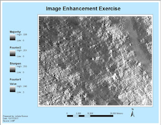
The initial image we worked with in ERDAS had a lot of strip down the entire image... it was intimidating. Then I was able to reduce the stripping by applying a blocker to bright spots via a Fourier image. I learned that this effect helps the stripes blend in. Out of curiosity, I applied a second Fourier image this time without a LowPass effect and found that it greatly improved the clarity of my image.
A second enhancement was done in ArcMap using the Focal Statistics tool which performs statistical tests using adjustable kernel of many shapes and sizes, and also calculates individual values for every cell. In the provided exercise, I tested Mean and Range values. In my final image I applied a Statistic Type Majority with 7Hx7W.
The most image enhancing I've done in the past has been in Photoshop. Learning these new image enhancing processes for larger images was very interesting to me as a lot of these filters require you do a lot of experimentation before getting the desired outcome. There is much more to learn.


Thank you very much for your informative and Educative post. I think it is very useful content for every person. Again thanks for sharing with us.
ReplyDeleteclipping path service